Available Crop Acreage Products
- Crop Area eReports (Current Scheduled Delivery: Monthly, throughout the growing season. Ad hoc delivery requests: up to 24 – 72 hour turn around)
- Crop Area GIS maps (Current Scheduled Delivery: Monthly, throughout the growing season. Ad hoc delivery requests: up to 24 – 72 hour turn around)
GDA crop area assessments are available for all major commodity crops globally at administrative sub-national levels. GDA focuses on operational delivery of crop acreage intelligence that improves the timeliness and accuracy of current and projected crop commodity information.
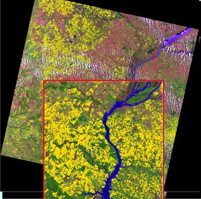
GDA uses current multi-resolution satellite imagery for crop mapping and area assessments. Crops are mapped at the field level. GDA crop mapping is supported by a proprietary GIS expert system.
Crop area statistics are provided per administrative unit starting with country level and drilling down to the finest administrative level of interest. The crop statistics are presented in tabular, graphic, and map forms and relate current season to the previous year, average/typical season, and other historical seasons. Absolute and relative (% difference from previous year and historical average) values as well as historical trend and 5-year average values are provided. Furthermore, crop maps can be requested in a GIS format.

Sample Crop Area Image product for Soybeans (Yellow Regions) in an AWiFS scene
Please contact us about purchase information.
