Cloud And cloud Shadow Assessment—CASA Software
“Automated Feature Extraction in Medium and High Resolution VNIR Imagery”

Project Abstract | What is CASA? | Example CASA Outputs |CASA Validation | More Information on CASA
Cloud contamination remains a RS industry-wide problem with generally unsatisfactory solutions to date. Available automated cloud detection procedures are tailored to a specific sensor, rely on the use of thermal and multispectral data, and are limited in their per-pixel quality. These shortcomings limit the applicability of existing algorithms to the wide range of commercial and governmental imagery.
A novel approach to automated Cloud And cloud Shadow Assessment (CASA) has been developed by GDA Corp. The major difference of the GDA approach from other operational algorithms lies in its (i) departure from exclusively spectral cloud detection through the introduction of spatial and contextual assessments along with hierarchical self-learning logic, (ii) independence from thermal data and ability to rely on Visible-NIR bands, and (iii) identification of not only clouds but also cloud shadows. CASA is applicable to a wide range of sensors, particularly to high-resolution commercial space- and air-borne imagery.
The novel, high-performance design was tested on over 450 scenes covering several different governmental and commercial sensors.
Development of these innovative algorithms addresses the need for streamlined acquisition and automated, operational processing of large volumes of RS data either at the ground station/processing facility, or on-board via FPGA implementation.
Contact GDA Corp. for additional information and licensing options: casa@gdacorp.com
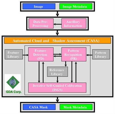
CASA is a fully automated software program for the per-pixel detection of clouds and cloud shadows from medium- (e.g., Landsat, SPOT, AWiFS) and high- (e.g., Ikonos, QuickBird, OrbView) resolution imagery without use of thermal data.
CASA was built using an object-based feature extraction paradigm which utilizes a combination of spectral, spatial, and contextual information available in the imagery and a hierarchical self-learning logic for accurate detection of clouds and their shadows.
CASA utilizes invariant pattern recognition techniques which are independent of the rotation and scale of the object to identify features of interest.
CASA requires no other inputs beyond the image in question and associated metadata. It works with images in their native data type (e.g., 8-bit data for Landsat 5 TM and Landsat 7 ETM+, 11-bit data for Ikonos and QuickBird) and accepts co-registered, geo-referenced bands either in radiometrically "raw" Dn value format, calibrated radiance, or top-of-atmosphere (TOA) reflectance.
No thermal imagery is needed!
CASA supports GeoTIFF and Erdas IMAGINE .img input formats. Other formats can be readily incorporated (e.g., NITF).
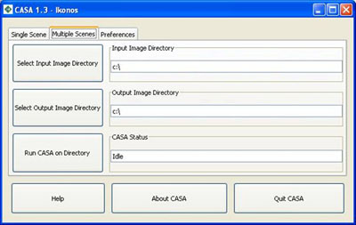
CASA is a stand-alone, platform-independent program that can be run on Windows, Linux, and UNIX.
CASA has a simple GUI and Open Source Viewer for non-GIS/non-programming experts, or can be called via a batch program within any COTS image processing/GIS software program in order to seamlessly integrate it into a standard pre-processing / production sequence. CASA can be run on a single scene or multiple scenes at once by specifying an input directory.
CASA outputs include:
- Raster mask image presenting per pixel cloud and cloud shadow contamination of the scene. Different IDs are assigned to dense clouds, light clouds / haze, and cloud shadows.
- Text file with scene total and per quad percent cloud and cloud shadow contamination and an accuracy measure of cloud detection. (Auto-update of the meta file can also be selected).
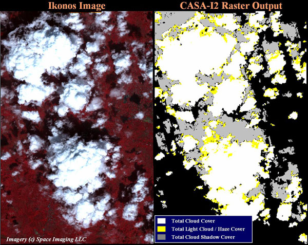
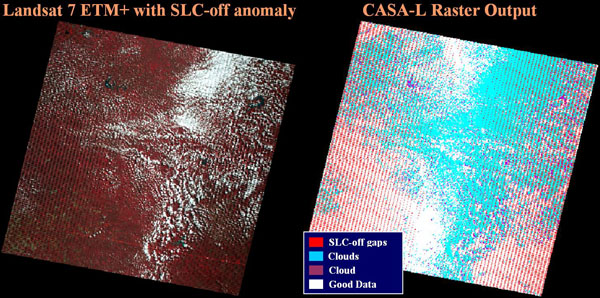
Example CASA Outputs: Text
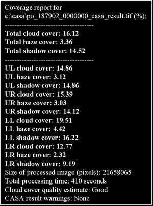
Validation studies have proven the reliability and accuracy of CASA to Landsat and Ikonos data. Promising preliminary validation results were also obtained for QuickBird and ADS40 imagery. Work is underway to validate the algorithms for AWiFS imagery.
Landsat 5 TM and 7 ETM+ Validation Results—Brief Synopsis
The accuracy of CASA-L (for Landsat 5 TM, Landsat 7 ETM+, and Landsat 7 ETM+ with SLC-off anomaly imagery) was assessed via comparison with the results generated by an independent visual assessment of cloud contamination in the imagery and re-implementation of NASA’s ACCA (Automated Cloud Cover Assessment), the established standard cloud detection algorithm for Landsat imagery. While ACCA relies heavily on the use of thermal data channels present in the Landsat sensors, CASA requires only the VNIR data.
A diverse set of 191 Landsat 5 TM and 7 ETM+ images was collected to assess the performance of the CASA-L algorithm. The dataset encompassed imagery for four regions, including: (1) the U.S. Western/Pacific, (2) the U.S. Eastern/Atlantic, (3) tropical areas of South America, Africa, and Indonesia located between 23.5oN and 23.5oS, and (4) polar areas of Russia and North America located north of 60o latitude. The aim of the collection was to obtain approximately fifty scenes per region, covering different seasons and various cloud, haze, and ground conditions.
|
Distribution of cloud contaminated scenes in the validation dataset |
A “truth” cloud dataset was generated by conducting visual assessments of per scene percent cloud cover. For each scene, two independent assessments of cloud cover were made. Results were then compared and cases of significant disagreement were resolved by scene re-evaluation by both operators simultaneously. Cloud cover mean and standard deviation values were calculated from the visual assessments and recorded for each scene. For images in which percent area cloud cover was hard to determine precisely, due to an abundance of small clouds or hazy areas that lacked distinct cloud / clear sky differentiation, a relatively large margin of error was specified for the visual estimate.
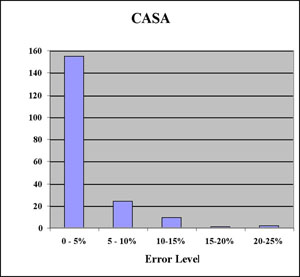 |
Summary of CASA-L results vs. visual (truth) estimate of cloud cover: Differences by level of error |
Validation results indicate that CASA-L performs as well or better than ACCA in a majority of the 191 Landsat images tested. While ACCA relies heavily on thermal band data which may be unavailable from future medium-resolution sensors, CASA-L achieves comparable and, in many cases, superior accuracy without the use of any thermal band data. Furthermore, CASA-L analysis provides information on not only clouds, but also cloud shadows.
Overall, CASA-L is within 10% of the visual estimate for 94% of all images tested, and within 5% for 81% of all images tested.
GeoEye’s Ikonos-2 Validation Results—Brief Synopsis
The current version of CASA-I2 has been validated on 216 Ikonos scenes for various areas, seasons, atmospheric, and ground conditions. Each scene was visually inspected to assess, separately, percent dense cloud cover, percent light, transparent cloud and haze cover, and percent of total cloud and light cloud / haze cover. For each scene, two independent assessments of cloud cover were made. Then, results were compared and cases of significant disagreement were resolved by scene re-evaluation simultaneously by both operators.
| % Cloud Cover | Cumulative Percent of Scenes | ||
| Dense Cloud Cover | Light Cloud / Haze Cover | Total Cloud & Haze Cover | |
| 0 to 10% | 65% | 82% | 56% |
| 0 to 30% | 80% | 95% | 74% |
| 0 to 50% | 85% | 100% | 81% |
| 0 to 70% | 86% | 100% | 84% |
| 0 to 90% | 93% | 100% | 87% |
| Max Cover | 100% | 53% | 100% |
Distribution of cloud and light cloud / haze contaminated scenes in the Ikonos validation dataset
The correlation values between the CASA-I2 results and the “truth” cloud dataset (visual estimates) are:
- Dense clouds: 95.5%
- Light, transparent clouds and haze: 62.1%
- Combined, clouds and haze: 94.4%
The correlation values between the Ikonos metadata and the “truth” dataset (dense cloud cover) values is 84.2%.
CASA-I2 statistically correlates with visual cloud estimates very closely.
Overall, CASA-I2 is found to be within 10% of the visual estimate for more than 90% of all images tested.
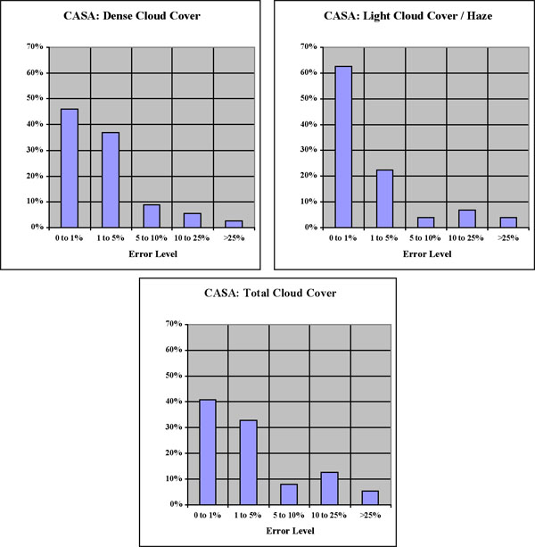
Summary of CASA-I2 vs. visual (truth) estimate of cloud cover: Differences by level of error
| Error Level | Cumulative Percent of Scenes | ||
| Dense Cloud Cover | Light Cloud / Haze Cover | Total Cloud / Haze Cover | |
| 0 to 1% | 46% | 63% | 41% |
| 0 to 2% | 62% | 76% | 52% |
| 0 to 5% | 83% | 85% | 74% |
| 0 to 10% | 92% | 89% | 82% |
| 0 to 15% | 95% | 93% | 87% |
| 0 to 25% | 98% | 96% | 95% |
| Max Error | 58% | 43% | 57% |
CASA-I2 vs. visual (truth) estimate of cloud cover: Differences by level of error
Download PDF’s with detailed CASA Validation Results!
Landsat 5 TM and 7 ETM+ Validation White Paper (CASA-L)
IKONOS Validation White Paper (CASA-I2)
AWiFS Validation White Paper (CASA-AW)
More Information on CASA
Automated, per-pixel Cloud and Cloud Shadow Assessment (CASA) Software:
- CASA-L (Landsat 5 TM and Landsat 7 ETM+ imagery)
- CASA-I2 (Ikonos2 imagery)
- CASA-QB (QuickBird imagery)
- CASA-AW (AWiFS imagery)
Download a CASA-L Brochure/Specification Sheet
Download a CASA-I2 Brochure/Specification Sheet
Contact us for additional information and licensing options: casa@gdacorp.com
