RASTA-DST—Decision Support Tools for Remotely sensed Agricultural STAtistcs
“Automated Extraction of Crop Area Statistics from Medium-Resolution Imagery”
Rapid, operational agricultural assessments are critically important for estimating country-level crop production. Access to accurate crop intelligence data ultimately leads to better market decisions and can help to develop new markets for U.S. agricultural products. Being able to confidently provide early warning of unusual crop conditions or changes in the production outlook of a country or region can assist the private marketplace in price determination and adjustment, thereby minimizing the risk of market manipulation.
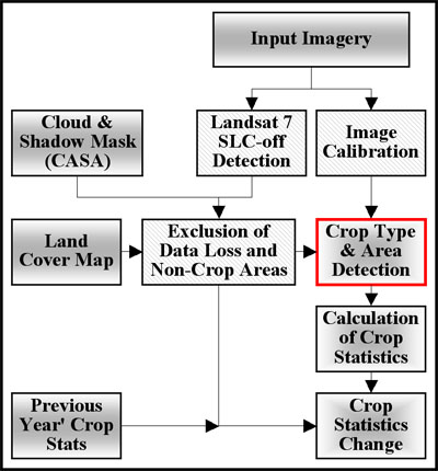
In this project, GDA Corp. is focusing on the strategic, routine incorporation of medium-resolution satellite imagery into operational agricultural assessments for the global crop market. Automated algorithms for rapid extraction of field-level crop area statistics from Landsat and Landsat-class imagery are being developed. In order to prototype the Remote Sensing-derived agricultural area statistics procedure, GDA Corp. is collaborating with the Production Estimates and Crop Assessment Division (PECAD) of the USDA Foreign Agricultural Service. The algorithms, based on Bayesian Probability Theory, incorporate multiple lines of evidence in the form of prior and conditional probabilities and implement an innovative approach to supervised image classification allowing for automated class delineation. The knowledge-based expert classifiers prototyped during this phase are being tested and validated at selected pilot sites across the globe.
 |
Outline of the Prototype RASTA-DST and Sequence for Crop Area and Type Assessment |
The application of this new technology will be less labor intensive and will therefore be more cost effective than current approaches. The project results will significantly increase the value and accuracy of field-level crop area assessments.
The project will serve to:
- Increase the accuracy, frequency, and spatial resolution of crop information available to crop analysts
- Improve statistical crop assessments with medium-resolution imagery
- Provide analysts with data on year-to-year changes in planted crop types and acreages for any scene footprint
- Improve input data for the crop yield models
