Under Shadow Feature Enhancement in Remotely Sensed Data
GDA Corp. is developing Remote Sensing (RS) software which will allow near-real time, automated under-shadow feature enhancement (USFE). The USFE software will be applicable to high resolution imagery, especially to data collected over urban environments. It will be of a particular use in scenarios where large volumes of data must be analyzed in near-real time. The prototype USFE software will be developed for optical systems and can be later extended to other sensors (e.g., thermal, active).
 |
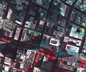
An example of information degradation and loss in RS data due to shadowing. Band combination: NIR-R-G. ADS40 imagery, courtesy of EarthData International. Variables contributing to the presence and severity of shadow contamination include solar elevation, view angle, data resolution, and surface type. Shadow contamination is particularly pronounced at lower solar elevation, in high resolution data, and for heterogeneous surfaces. |
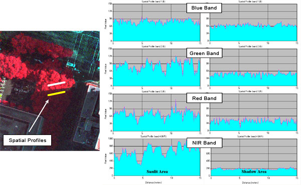
USFE addresses all sources of data degradation in shaded areas, which are: (1) a drop in pixel values due to the shadow depth and (2) an object/target-specific decline in the dynamic range of pixel values. The USFE improves degraded under-shadow information by automatically modeling the depth of each shadow and measuring a target’s dynamic ranges under and outside of the shadows. To cover scenarios when a DSM is not available or cannot be generated due to data (e.g., non-stereo) and/or time constraints, USFE is capable of simulating a DSM from a single image.

Data degradation due to the shadowing of the object
USFE implements innovative techniques utilizing spectral, spatial, and contextual information and includes optional digital surface model (DSM) simulation from the imagery. USFE adapts and expands a number of GDA’s existing techniques dealing with topographic normalization, probability measures, and near-real time automated feature and pattern recognition in RS data.
