A Semi-Automated GIS Expert System for Stream Network and Riparian Buffer Delineation in High-Resolution Imagery
“Geospatial techniques to align vector and image raster data in the presence of spatial mismatch and obscured data scenarios”
Update: A prototype software package demonstrating the STREAM-TRACE technology has been provided to a number of users associated with the Chesapeake Bay Program. Visit www.gdacorp.com/projects/RBMapper.html for information on how to obtain a demo version of this software, or to unlock an existing demo version.
GDA Corp. is developing a semi-automated GIS expert system – STREAM-TRACE – for stream buffer delineation in high-resolution imagery (HRI). The system fulfills the need for specialized GIS tools to improve and simplify the analysis of HRI.
While commercial software packages are available for classifying HRI, they do not adequately account for spatial and particularly contextual information to ensure classification accuracy, require highly skilled users, and often rely on inefficient processing algorithms. Furthermore, currently existing schemes for stream buffer delineation and land cover assessment rely on disparate sources of spatial information, including water vector datasets digitized from DOQQs and topographic maps and land cover information obtained through the analysis of less detailed, medium resolution imagery. Spatial datasets used in such schemes typically have different resolutions, levels of accuracy, and represent different acquisition/generation dates. These sources of data commonly exhibit spatial mismatch in location and/or level of detail for the water features present in both datasets. This leads to spatial misrepresentation of water features, stream buffers, and land cover estimates in the final result of the analysis.

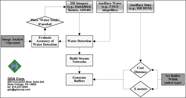
GDA’s STREAM-TRACE: A semi-automated expert system for detection of water features and stream networks present in the HRI and delineation of stream buffers.
GDA Corp.’s expert system overcomes the limitations of current state-of-the-art schemes by directly analyzing HRI and identifying locations of water features present within the scene. The results therefore match the resolution and date of the analyzed HRI. The system’s analytical capabilities rely on digital HRI such as space-borne data (e.g., Ikonos and OrbView sensors from Space Imaging / GeoEye LLC and QuickBird sensor from Digital Globe LLC) and air-borne data (e.g., from Leica’s ADS40 camera). Digital HRI is typically collected in 3 visible bands (blue, green, red), a near-infrared band, and a higher resolution panchromatic band and, as a rule, is delivered in georeferenced format. Furthermore, an orthorectified, at sensor corrected, and/or mosaiced imagery along with DEM/DSMs can also be requested from vendors or 3rd parties. Given the digital HRI band combination, radiometric properties, large dynamic range of up to 14 bit dynamic range (versus the usual 8 bit), a very good signal to noise ratio, and spatial resolution from 4 meters to sub-meter, this data is well-suited for water delineation and land cover mapping of riparian buffers.
GDA’s STEAM-TRACE system exploits spectral, spatial, and contextual information present in the scene to delineate water features. Information from ancillary hydrological vector datasets is also utilized as an additional line of evidence in water delineation from the image. To ensure the accuracy of water delineation, the system allows for in-process inspection of the results by the image analyst / operator and, if required, an editing of the results. Two options for delineation of water buffers are provided. To identify buffer boundaries, an image analyst / operator is required to either specify a simple distance (in meters or pixels) from the stream or to state the cost relation between the DEM slope and a friction value for a cost-weighted distance function.
STEAM-TRACE allows for improved delineation and inventory of riparian buffers. The system is semi-automated and requires very limited user training.
