Remote Sensing-based Decision Support Tools for Rapid environmental Assessment, Monitoring and Management
“Bridging the gap between RS data providers and applicational users”
GDA Corp. is developing web-based decision support tools (DST) to assist in Rapid Assessment, Monitoring, and Management (RAMM) on a regional scale. The RAMM-DST will supplement operational decision support systems (DSS) already in use with value-added, customized data products routinely derived from government and commercial remotely sensed data. Delivery of data products and information will be through a web portal where users can query, order, and download data for a specified area and time period of interest in a format that fully meets user needs and requirements.
In order to prototype and illustrate real-world use of the system, GDA is collaborating with the Chesapeake Bay Program (CBP), as well as the U.S. EPA BASINS program, to derive customized, value-added data products for regional water modeling, monitoring, and decision-making. CBP and EPA/BASINS are considered national and international models for implementing successful watershed research and restoration projects. Products and services developed through this effort will have wide applicability within the national Watershed Modeling (WSM), Water Quality (WQ) Analysis and Monitoring, and TMDL development community which needs data to support their data-intensive operational DSS.
The prototype web portal is available at www.customRS.com.
The following value-added products are in the development pipeline:
- Meteorological Data: Temperature, Precipitation, Evapotranspiration, Wind Speed, Snow Cover, Snow Depth, Snow Water Content, Soil Moisture, Cloud Cover
- Water Properties: Water Clarity, Chlorophyll-a
- Land Cover: Land Cover, Land Cover Change
- Phenology: Forest and Crop Phenology
These data will be derived from a variety of Remote Sensing data sources, including NASA’s Moderate Resolution Imaging Spectroradiometer (MODIS) sensor and NASA’s Advanced Microwave Scanning Radiometer - EOS (AMSR-E) sensor. The MODIS sensor, for example, views the entire Earth's surface every 1 to 2 days, acquiring data in 36 spectral bands and provides daily data on a number of important environmental parameters at resolutions starting at 250 meters. The AMSR-E sensor observes atmospheric, land, oceanic, and cryospheric parameters, including precipitation, sea surface temperatures, ice concentrations, snow water equivalent, surface wetness, wind speed, cloud water, and water vapor.
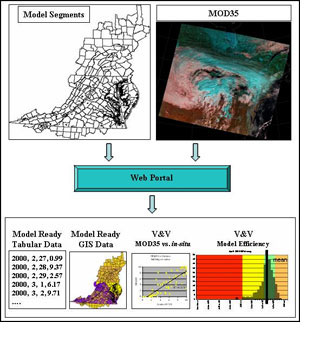
The approach proposed by GDA allows for highly customized, yet flexible generation of data that is ready for direct model input and model calibration and validation. Data for specific watershed and water quality models will be provided in a format that fully meets model specifications. For example, users of the Hydrological Simulation Program—Fortran (HSPF) will be provided with data in HSPF-native (.wdm) file format. Users will also be provided with ready-made, standard datasets aligned with, for example, hydrologic unit code (HUC) boundaries as many agencies partition basins in this manner and report in-situ data to this level. Primary interaction with users will be through the web portal where, by either completing on-line request forms or selecting from pre-packaged data, the user will be able to request the data theme, time period, frequency, area of interest, spatial aggregation-level, data/file format, delivery mechanism (e.g., email, FTP push, FTP pull), etc. A staffed helpline will also be provided for users with specific questions, etc.
Visit customRS for a sample real-world case study that presents the evaluation, and verification and validation of a MODIS data product for infusion into the CBP Watershed Model. |
An example of daily cloud cover data, provided by GDA, for input into CBP’s hydrological submodel of the HSPF Watershed model. Data is derived from NASA’s MODIS satellite sensor. Cloud cover percentages are computed per model (sub-basin) segments and outputs are automatically provided in two formats: (1) 370 ASCII-formatted text files (one per segment), with columns corresponding to MODIS acquisition year, month, day, and calculated per segment percent cloud cover and (2) a vector ESRI shapefile in UTM-18n showing per segment percent cloud cover for a given MODIS observation. |

